Our planet is the best mystery box. In other words, it is filled with many unknown and unusual facts. From the minus temperatures in poles to the scorching heat of equator, from the largest ocean to the smallest island, etc. Geography of this world is more diverse than anyone can imagine. The more we try to unlock its secret, the more anomalies and mysteries we discover. We have brought 20 such mind-boggling geographical facts together.
1 Diomede Islands are constituted of two islands. One is owned by Russia and the other one by America. The distance between both islands is 2.4 miles but the time difference is 21 hours!
Diomede Islands are made up of two islands, the Big Diomede and the Little Diomede. The Big Diomede is under Russian administration while the Little Diomede is under the American administration. Â The distance between the two islands, which is the closest distance between US and Russia, is just 2.4 miles (3.8km). However, surprisingly these two islands have a time difference of 21 hours. The Big Diomede is 21 hours ahead of Little Diomede. This large time difference is due to the International Date Line which passes between the two islands. Due to this, Big Diomede is called Tomorrow Island and Little Diomede is called Yesterday Island. (source)
2 The Chamarel plain in Mauritius has a small area of sand dunes made up of sand in seven distinct colors.Image credits: Martin Falbisoner via wikimedia
The Chamarel plain located in the Riviere Noire District of south-western Mauritius is famous all over the world for its Seven colored earth. In fact, it is an area of sand dunes consisting of sand that has seven distinct colors. As the sunlight hits the dunes, the seven colors can be seen visibly. The colors of the sand is a result of a difference in cooling of molten volcanic rock. The difference in cooling occurred when the different portions of the molten volcanic rock got cooled at different temperatures. Lastly, the best time to view these colors is the morning when the dew mingled sand brings out its brightest hue.(1,2)
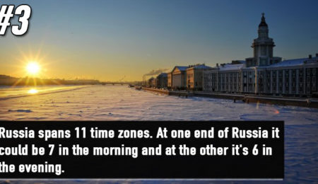
3 Russia is so large that it spreads over 11 different time zones. When one side of Russia has a morning breakfast at 7 am; the other side enjoys evening snacks at 6 pm.Image credits: pixabay
Russia is the largest country in the world. It spreads over 17,075,200 square km area and over 11 time Zones. Thus, the current time range observed by Russia is UTC+02:00 to UTC+12:00. Hence, apparently, while one part of Russia enjoys the morning sun, the other part enjoys the sunset. (source)
Advertisements
4 75% of all fresh water available on earth is stored in the glacier. Also, Lake Baikal in Russia contains 20% of the total non-frozen fresh water available on our planet.Image credits: Martin St-Amant via wikimedia
About 15 million square kilometers of land is covered with glacier which is about 10% of the total land area on our planet. If all the glaciers melt, the sea level all over the world would rise by approximately 70 meters. These glaciers contain 75% of the total fresh water available in the world.
Lake Baikal in Russia contains 20% of the total non-frozen fresh water available on our planet. It is the oldest and deepest lake in the world and is famous for its crystal clear water. The immense Lake Baikal spreads over an area of 31,722 square kilometers due to which it is often mistaken for a sea. Unfortunately, it is currently under threat due to poaching, pollution, and development. (1,2)
5 Reelfoot Lake in Tennessee was created due to the impact of three earthquakes, which occur in 1811 and 1812, measured around 8 on the Richter Scale.Image credits: JeremyA via wikimedia
In 1811 and 1812, three earthquakes shook New Madrid. The third earthquake with a magnitude of 7.5 to 8 pushed water into a basin which led to the formation of Reelfoot Lake near Tiptonville, Tennessee. During these earthquakes, people witnessed that the Mississippi River had started flowing backward. Yet, scientific studies have shown that the earthquake produced northwest moving water waves which created the illusion that the Mississippi river was flowing backward for a few hours. (source)